Technické údaje
Technické parametry:
BR je navržena dle ČSN 73 6110 Projektování místních komunikací, ve znění změny 2 z roku 2003, jako místní, směrově rozdělená, komunikace. Územní plán hlavního města Prahy konstatuje, že uliční síť nadřazených sběrných komunikací celoměstského významu v pásmu mezi Silničním (SO) a Městským okruhem (MO) je navrhována jako soustava sběrných radiálních komunikací (RK) městského charakteru ve funkční třídě B1. Parametry těchto komunikací jsou navrženy diferencovaně podle dopravní důležitosti jednotlivých tras a okolní zástavby. Podle doslovné citace ÚPn Břevnovská radiální komunikace (BR) obsluhuje území Řep, Bílé Hory a Břevnova a navazuje na vstup silnice R6 směrem do města.
Uspořádání napojovacích uzlů (křižovatek) je v hlavní trase BR výlučně mimoúrovňové (křižovatky Řepy, Slánská, Vypich i Malovanka mimoúrovňové jsou), na okolní komunikační síti, která je stavbou BR dotčena a na komunikacích souvisejících s vlastní BR (například obslužná komunikace na stropě BR v ulici Patočkova) jsou navrženy křižovatky úrovňové. Počet mimoúrovňových či úrovňových křižovatek ovlivňuje skutečnost, která varianta řešení je ve kterém úseku trasy použita.
Břevnovská radiála je navržena v kategorii MS 20/60, v šířkovém uspořádání 2×2 průběžné jízdní pruhy s připojovacími a odbočovacími pruhy, bez nouzových pruhů, avšak s nouzovými zálivy, a se středním dělícím pásem s fyzickým oddělením protisměrné dopravy v zájmu bezpečnosti. Šířka dělícího pásu je ovlivněna řešením v extravilánu, zahloubeným, zakrytým a tunelovým. Návrhová rychlost 60 km/hod. je považována za minimální s ohledem na stísněné poměry v zástavbě, s ohledem na homogenitu navazujících staveb MO je trasa navržena na 70 km/hod. To je zcela v souladu s revizí normy ČSN 73 61 01 – Projektování silnic a dálnic a termínu „směrodatná rychlost“. S ohledem na podélný profil trasy nejsou v žádných úsecích trasy potřebné pruhy pro pomalá vozidla. Směrové parametry křižovatkových ramp jsou řešeny s ohledem na funkční třídy napojovaných povrchových komunikací, minimální návrhová rychlost je 35 km/hod, většinou však 50 km/hod.
Výsledné uspořádání jízdních pásů navržené BR (mimo zahloubené a tunelové úseky) vychází v definitivní podobě z ČSN 73 61 10, kategorie MS 20/60:
Volná šířka jízdního pásu b1, b2 = 9,00 m mezi líci svodidel nebo směrovými sloupky.
- Uspořádání pro b1, b2 = 9 m: 0,5 + 0,5 + 3,50 + 3,50 + 0,5 + 0,5
- Šířka středního dělícího pásu závisí na technickém řešení úseku a je navržena šířky:
- Volná trasa násyp, zářez, odřez – 3,0 m
- Zakrytá nebo zahloubená trasa – střední stěna
- Ražená tunelová trasa – horninový pilíř
- Dva samostatně vedené pásy – nejsou navrženy
Vzhledem k požadovanému profilu bez nouzových pruhů jsou s ohledem na vysokou intenzitu dopravy navrženy bezpečnostní zálivy. Tyto bezpečnostní zálivy jsou nezbytné pro minimalizaci vzniku překážek v plynulém provozu ve 2 jízdních pruzích každého pásu. Zálivy jsou navrženy ve vzdálenosti cca 600m. V těchto místech je komunikace je rozšířena o jeden jízdní pruh šířky 3,5 m na délku 40 m s příjezdovým náběhem 1:1 a výjezdovým náběhem 1:2 (stejně jako v tunelových úsecích).
V souladu s požadavkem Policie ČR jsou všechny výjezdní rampy navrženy jako dvoupruhové pro umožnění evakuace vozidel z tunelů.
Zatím co první studie předpokládaly zcela povrchové řešení BR, s klasickými zářezy a násypy, postupně narůstal tlak na ochranu před hlukem a exhalacemi i požadavky dotčených orgánů natolik, že
Šířkové uspořádání komunikace procházející tunelem nebo zahloubenou trasou se svislými stěnami obsahuje směrově rozdělenou 4 (6) pruhovou komunikaci s šířkou jízdního pruhu 3,5 m. Protisměrné komunikace jsou vždy vedeny v samostatném tubusu hloubeného tunelu se společnou střední stěnou. Po obou stranách komunikace jednoho směru jsou umístěny vodící proužky šířky 0,25 m, a chodníky v šířce 1,0. Do šířky chodníku lze ještě započítat nevyužité tolerance konstrukce stěn tunelu, jejichž hodnota dosahuje max. 0,15 m. Příčný sklon v přímé je stanoven jednotně na 2,5 %. Výška průjezdného profilu je 4,5 m.
SOS výklenky s požárním hydrantem jsou umísťovány do vzdálenosti max. 300 m. Nouzové zálivy v tunelu mají výšku průjezdného profilu 4,2 m. V místech SOS výklenků a nouzových zálivů je vždy možnost úniku mimo tubus tunelu přímo na povrch, nebo přes propojku do vedlejšího tubusu (ražené tunely).
Průjezdné profily v tunelových objektech jsou navrženy dle ČSN 73 7507 Projektování tunelů pozemních komunikací a podle posledního platného návrhu revize příslušné „tunelářské“ normy.
Hlavní parametry prostorového uspořádání v tunelových úsecích jsou následující:
šířka jízdního pruhu 3,50 m
šířka vodícího proužku 0,25 m
šířka vozovky mezi obrubníky pro dva jízdní pruhy 7,50 m (kategorie T-7,50)
oboustranný nouzový chodník šířky 1,00 m
výška obrubníku 0,15 m
základní výška průjezdního průřezu 4,50 m
Dopravně kapacitní dimenzování jednotlivých částí navrhované trasy včetně připojovacích a odbočovacích ramp a uspořádání řadících pruhů v povrchových napojovacích uzlech BR vychází z dopravního modelu firmy CityPlan. Původně byl dopravní model zkalibrován na základě zátěžových výpočtů z matic dopravních vztahů předaných odborem SÚRM Magistrátu hl.m.Prahy k návrhovému horizontu roku 2010, v současnosti se zcela opírá o sčítání na vybrané síti komunikací na území hlavního města Prahy podle ÚDI z roku 2007, promítnuté do prognózy dopravních výkonů, která byla podrobně prověřována pro aktualizaci dopravních zátěží jednotlivých staveb SOKP.
Připojení BR na okolní komunikační síť je uvažováno ve 4 uzlech:
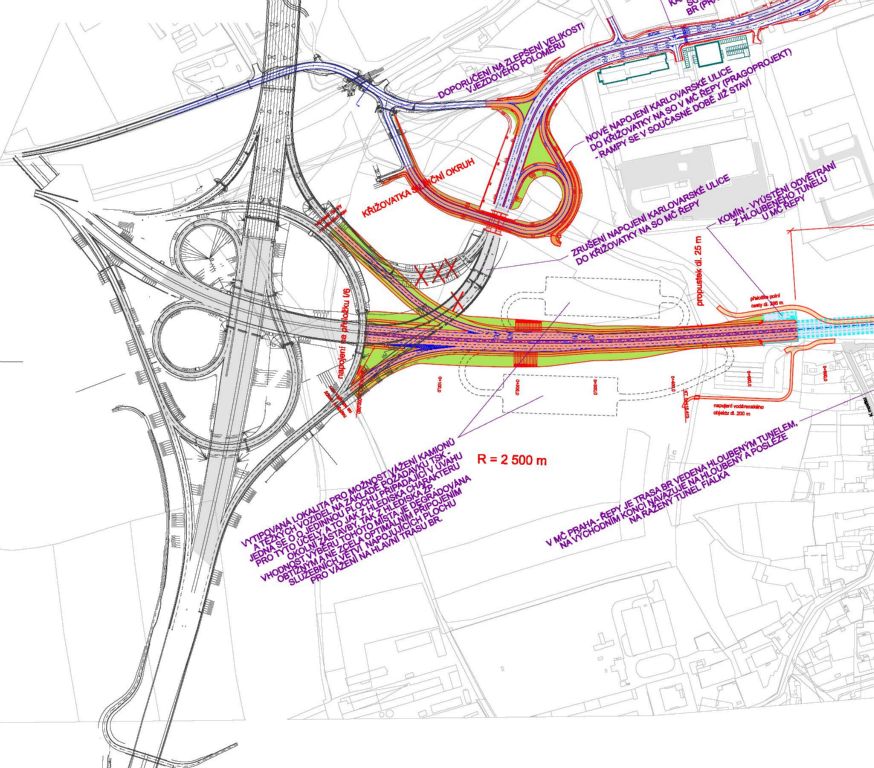
Křižovatka v napojení BR do Silničního okruhu (R1) v MÚK Řepy
- BR navazuje přímo na trasu rychlostní komunikace R 6.
- Křižovatka umožňuje jízdu z/do všech 3 směrů, tedy R 6, SOKP sever, SOKP jih.
- Křižovatka neumožňuje napojení Karlovarské (provizorní napojení bude zrušeno). Napojení na Hostivice bude možné až z křižovatky Jeneč, nebo z (uvažované) křižovatky Hostivice – východ.
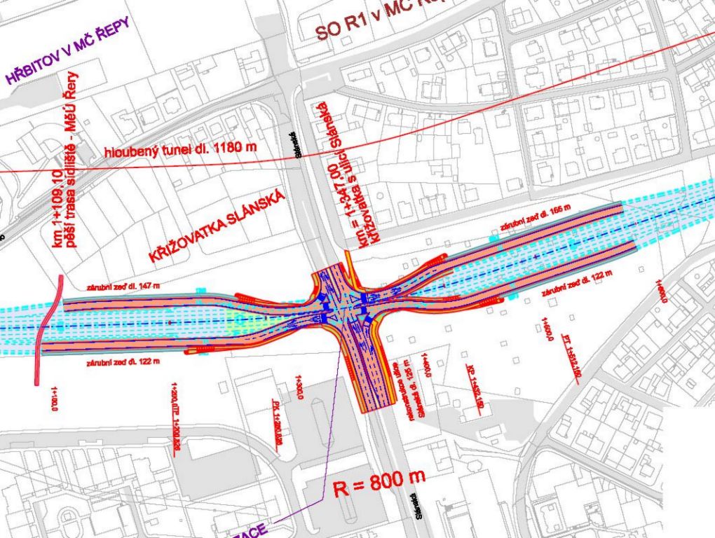
Křižovatka BR – Slánská
Křižovatka Slánská představuje vůbec nejkontroverznější část výstavby Břevnovské radiály, která budí odpor MČ Praha 17 (Řepy) vůči stavbě. Je třeba upozornit, že tato křižovatka bude hlavním napojovacím bodem celé části MČ Řepy na trasu BR, potažmo na trasu SOKP. V případě její nerealizace nedojde k očekávanému výraznému odlehčení stávající ulice Karlovarská a odvedení průjezdné dopravy od obytné zástavby. Při nerealizaci MÚK Slánská dojde k celkovému přitížení okolní komunikační sítě v širším rozsahu.
- Křižovatka byla prověřena v řadě tvarů a v různých alternativách. V současné době je jediným invariantním řešením světelně řízená, průsečná křižovatka se 4 těsně připaženými rampami
- S křižovatkou nesouhlasila a i nadále nesouhlasí MČ Praha 17, a to i přesto, že je pro funkci BR a dopravní obsluhu tato křižovatka naprosto nezbytná. V rámci zpracovaných dokumentací byly prověřeny další varianty nahrazující tuto křižovatku. Jako poslední alternativní řešení přetrvává návrh podle námětu městské části Praha 17, který uvažuje s křižovatkou ve volném prostoru mezi SOKP a MČ Praha 17.
- Křižovatka byla dopravně prověřena dynamickou mikrosimulací a podrobně analyzována nejen jako samostatný prvek, ale v celém segmentu SSZ křižovatek na ulici Slánská – s ohledem na výsledky této analýzy je vyhovující pouze řešení se SSZ křižovatkou v místě křížení trasy BR s ulicí Slánská.
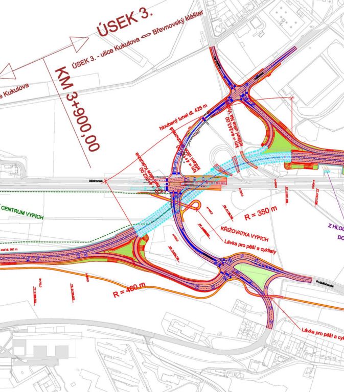
Křižovatka Vypich
- Je stabilizována již z Dopravní studie 2001 v ÚP a doposud zcela invariantní
- Vytváří 2 nové křižovatky ramp: Kukulova a Ankarská, které budou koordinovaně řízeny SSZ spolu se stávající křižovatkou Vypich.
- Provizorní ukončení Břevnovské radiály v této křižovatce s následným povrchovým pokračováním ve stávající ulici Patočkova je možné za předpokladu vybudování dvou provizorních ramp: BR směr Bělohorská (MO), a Bělohorská (MO) směr BR. Pokud by k takové etapizaci došlo, musí být rampy následně demolovány.
- Křižovatka Vypich (jako současný velmi vážný dopravní problém), je samostatně provozovatelná ve dvou možných provozních stavech, které by ulehčily úrovňové křižovatce Vypich – při realizaci v nulové variantě s uvažovaným novým propojením ulice Kukulova Břevnovská radiála značně odlehčuje prostoru stávající ulice Kukulova před Motolskou nemocnicí.
Křižovatka Malovanka (BR – Pod Královkou,- Malovanka – MO)
Tato křižovatka představuje jeden z nejsložitějších dopravních uzlů v Praze, který propojuje celkem 7. směrů. S ohledem na náročnost a kvalitní dopravní funkci tří velmi zatížených směrů (MO – Špejchar, MO – Strahovský tunel a BR) a jejich bezkolizní propojení není možné propojit všechny ostatní směry na dopravní síti nižšího řádu navzájem a vytvořit tak plnohodnotnou křižovatku umožňující všechny pohyby. V předchozích dokumentacích byla tato křižovatka důkladně zkoumána a výsledkem bylo zpracování velkého množství variant, od nulté, tedy řešení bez pokračování BR v zahloubené poloze, s dvěmi variantami křižovatky Pod Královkou (okružní nebo průsečná řízená) až po různé rampové uspořádání křižovatky Malovanka, lišící se možností kompletních pohybů, bezkonfliktností pohybů mezi BR a MO, a kvalitou průletových úseků.
Jelikož se jedná o klíčový problém fungování BR a vazby na MO a povrch, byl k této problematice přizván okruh dalších odborníků, (SÚRM, Policie ČR, PÚDIS – jako zpracovatel dokumentace stavby SAT 3A a 3B, křižovatka SAT Malovanka) aby došlo k nalezení shody na výsledném řešení.
Křižovatka Malovanka jako součást SAT je v současné době již v pokročilém stupni rozestavěnosti, proto a také vzhledem k náročnosti technického řešení byla jako výsledná varianta napojení BR přijata varianta označená 8.4.b (dle výkresové dokumentace Technické ověřovací studie).